
The ‘Ksan Historical Village at Hazelton, B.C. was built in the 1970s to replicate a traditional Gitxsan village with longhouses, totem poles and cultural artifacts from this rich indigenous culture. (Richard McGuire photo)
I spent two weeks from the end of May and into June 2016 on a long drive through northern B.C, the Yukon and into Alaska.
For those who haven’t followed my blog, here’s a sampling of photos from the trip. (© Richard McGuire Photo)


Cow Bay in Prince Rupert, B.C. used to be a somewhat ramshackle fishing port. Now it’s a harbour for boat tours and private recreational boats as well as more upscale bars, coffee shops and boutiques. (Richard McGuire photo)

Commercial fishing boats are moored at Rushbrook Harbour in Prince Rupert, B.C. (Richard McGuire photo)

Clouds hang over the mountains that line the inlet approaching Khutzeymateen Grizzly Bear Sanctuary. There’s a reason they call this the Great Bear Rain Forest. (Richard McGuire photo)

A female grizzly bear stands up while eating sedge grass at Khutzeymateen Grizzly Bear Sanctuary. (Richard McGuire photo)

Harbour seals chill out on a rocky island as they take a break from fishing in the Pacific Ocean near Khutzeymateen Grizzly Bear Sanctuary. (Richard McGuire photo)

A bald eagle swoops down for pieces of meat thrown from a tour boat near Prince Rupert, B.C. (Richard McGuire photo)

A bald eagle swoops down for pieces of meat thrown from a tour boat near Prince Rupert, B.C. (Richard McGuire photo)

They are artistic masterpieces and they inspired the painter Emily Carr, but the cluster of totem poles at Gitranyow are found in front of a humble gas bar in a not very prosperous First Nations community. They have stood for more than a century in some cases. (Richard McGuire photo)

Once a busy mining community, the quiet town of Stewart. B.C. sits in a spectacular location at the base of the mountains. Many of its old wooden buildings have a unique charm. (Richard McGuire photo)

A fishing boat makes its way out from Stewart harbour into the Portland Canal, an arm of the Pacific Ocean. (Richard McGuire photo)O

A black bear strolls next to the roadway between Stewart, B.C. and Hyder, Alaska. (Richard McGuire photo)

When you cross the international border from B.C. into Hyder, Alaska, there is no U.S. customs station. (Richard McGuire photo)

Anyone thinking of crossing the border for cheap U.S. gas in Hyder, Alaska will probably be disappointed. (Richard McGuire photo)

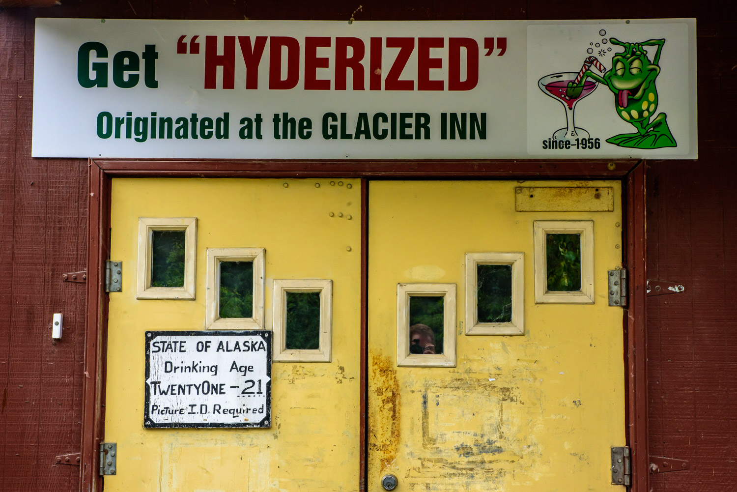
The tradition in Hyder is to “get Hyderized” by gulping back a shot of 190 proof grain alcohol. For that you receive a card attesting to your accomplishment. I gave this tradition a pass, in part because I was driving. (Richard McGuire photo)

Leaving Hyder, Alaska to go north, you pass by this wetland. (Richard McGuire photo)

Salmon Glacier snakes down a valley in B.C. just north of Hyder, Alaska. You drive up to about 1,000 metres in elevation, and there was still a considerable amount of snow at the roadside, although it was quickly melting. (Richard McGuire photo)

Salmon Glacier snakes down a valley in B.C. just north of Hyder, Alaska. You drive up to about 1,000 metres in elevation, and there was still a considerable amount of snow at the roadside, although it was quickly melting. (Richard McGuire photo)

Salmon Glacier snakes down a valley in B.C. just north of Hyder, Alaska. You drive up to about 1,000 metres in elevation, and there was still a considerable amount of snow at the roadside, although it was quickly melting. (Richard McGuire photo)

When I got back to Stewart, B.C. after a visit to Hyder, Alaska, the sun emerged, but it continued to pour rain. A rainbow was visible over Stewart off and on for over an hour. (Richard McGuire photo)

These purple lupins were growing in many places along the Cassiar Highway. (Richard McGuire photo)

A forest fire a number of years ago left spindles of dead trees over a large area, seem behind this peaceful lake off the Cassiar Highway. (Richard McGuire photo)

On the Alaska Highway the road stretches though miles of wilderness with snow covered mountains all around. (Richard McGuire photo)

The drive from Carcross, Yukon to Skagway, Alaska is only a little over an hour (minus numerous photo stops), but it’s one of the most beautiful drives in the world. It gets chilly as you climb through White Pass. (Richard McGuire photo)

The drive from Carcross, Yukon to Skagway, Alaska is only a little over an hour (minus numerous photo stops), but it’s one of the most beautiful drives in the world. It gets chilly as you climb through White Pass. (Richard McGuire photo)

It’s definitely a tourist town as the northern port for ships travelling the Inside Passage, but Skagway, Alaska has a unique charm with many older wooden buildings surviving from the Klondike era. (Richard McGuire photo)

One of the nice things for photographers in June in the Yukon is the long golden hours. I took this photo south of Carcross at 10 p.m. It wasn’t dark until after midnight. (Richard McGuire photo)

It was a rainy day when I drove to Haines Junction. That evening I went for a drive up to Destruction Bay on Kluane Lake, skirting Kluane National Park. The sun gradually emerged from the clouds, creating some dramatic weather. (Richard McGuire photo)

It was a rainy day when I drove to Haines Junction. That evening I went for a drive up to Destruction Bay on Kluane Lake, skirting Kluane National Park. The sun gradually emerged from the clouds, creating some dramatic weather. (Richard McGuire photo)

It was a rainy day when I drove to Haines Junction. That evening I went for a drive up to Destruction Bay on Kluane Lake, skirting Kluane National Park. The sun gradually emerged from the clouds, creating some dramatic weather. (Richard McGuire photo)

It was a rainy day when I drove to Haines Junction. That evening I went for a drive up to Destruction Bay on Kluane Lake, skirting Kluane National Park. The sun gradually emerged from the clouds, creating some dramatic weather. (Richard McGuire photo)

Quill Creek, south of Haines Junction. (Richard McGuire photo)

The Haines Highway south of Haines Junction passes by many beautiful lakes and mountains. (Richard McGuire photo)

The Haines Highway south of Haines Junction passes by many beautiful lakes and mountains. (Richard McGuire photo)

The Haines Highway south of Haines Junction passes by many beautiful lakes and mountains. (Richard McGuire photo)

Driving south on the Haines Highway from Haines Junction, the route passes into B.C. and skirts Tatshenshini Alsek Park. (Richard McGuire photo)

The Sign Post Forest at Watson Lake, Yukon has more than 100,000 place signs, distance signs, license plates and other signage left on posts by visitors from all over the world. It was started in 1942 by a homesick GI from Danville, IL, indicating 2,835 miles to his home town. Over the years it has grown so it it now is virtually a forest of signs. (Richard McGuire photo)

I spotted this black bear eating vegetation on the opposite side of the Alaska Highway from me. It saw me, but kept on eating as I watched with a long lens. This was taken in northern B.C. just south of the Yukon border near the Liard River. (Richard McGuire photo)

Muncho Lake Provincial Park in northern B.C. along the Alaska Highway offers some spectacular scenery as the highway passes through the Northern Rocky Mountains. (Richard McGuire photo)

Muncho Lake Provincial Park in northern B.C. along the Alaska Highway offers some spectacular scenery as the highway passes through the Northern Rocky Mountains. (Richard McGuire photo)

I tented at Mucho Lake Provincial Park on the Alaska Highway in the Northern Rocky Mountains, and I got up at 4 a.m. to catch the early light over Muncho Lake. (Richard McGuire photo)

I tented at Mucho Lake Provincial Park on the Alaska Highway in the Northern Rocky Mountains, and I got up at 4 a.m. to catch the early light over Muncho Lake. (Richard McGuire photo)

This female moose was grazing next to the Alaska Highway in Muncho Lake Provincial Park in northern B.C. This was taken near the Toad River. (Richard McGuire photo)

Porcupines aren’t the fastest of creatures, but they use their quills rather than speed as defence against predators. I was able to take a few shots of this one by the Alaska Highway before it waddled off into the bush. (Richard McGuire photo)

This is the official cairn for the start of the Alaska Highway, or Mile 0, in Dawson Creek, B.C. The more photographed marker is a couple blocks away. (Richard McGuire photo)