They shoot horses, don’t they?

I had a chance to do a photo shoot at a horse farm near Okanagan Falls, B.C. today with the Penticton Photography Club. (Richard McGuire Photo)

I had a chance to do a photo shoot at a horse farm near Okanagan Falls, B.C. with members of the Penticton Photography Club.

I had a chance to do a photo shoot at a horse farm near Okanagan Falls, B.C. with members of the Penticton Photography Club. These were actually mules, evident by the long ears. A mule is a cross between a donkey and a horse. They rarely have offspring.

I had a chance to do a photo shoot at a horse farm near Okanagan Falls, B.C. with members of the Penticton Photography Club. I love the articulating LCD screen on the D750, which lets me shoot from ground level.

I had a chance to do a photo shoot at a horse farm near Okanagan Falls, B.C. with members of the Penticton Photography Club. These miniature horses were just the cutest!

I had a chance to do a photo shoot at a horse farm near Okanagan Falls, B.C. with members of the Penticton Photography Club. Another shallow depth of field portrait — this time with my 70-200mm f/2.8.

Northern India 2015

Sadhus are Hindu holy men or ascetics who renounce their worldly possessions and wander in search of moksa, or spiritual liberation. There are many of them in the holy city of Varanasi on the Ganges River. (© Richard McGuire Photo)

I spent a month in India from late January until the end of February, flying to Delhi and visiting four states in the north. I was last in India 38 years ago and there have been a lot of changes, but a lot remains the same. See also my blog that I kept at the time, which starts in January 2015. © Richard McGuire Photo

My hotel room balcony overlooked the narrow and busy street of Main Bazar in New Delhi. There was a constant sound of honking horns and ringing bells as cars, motorcycles, rickshaws bicycles, pedestrians and pushcarts all competed for their bit of street. (© Richard McGuire Photo)

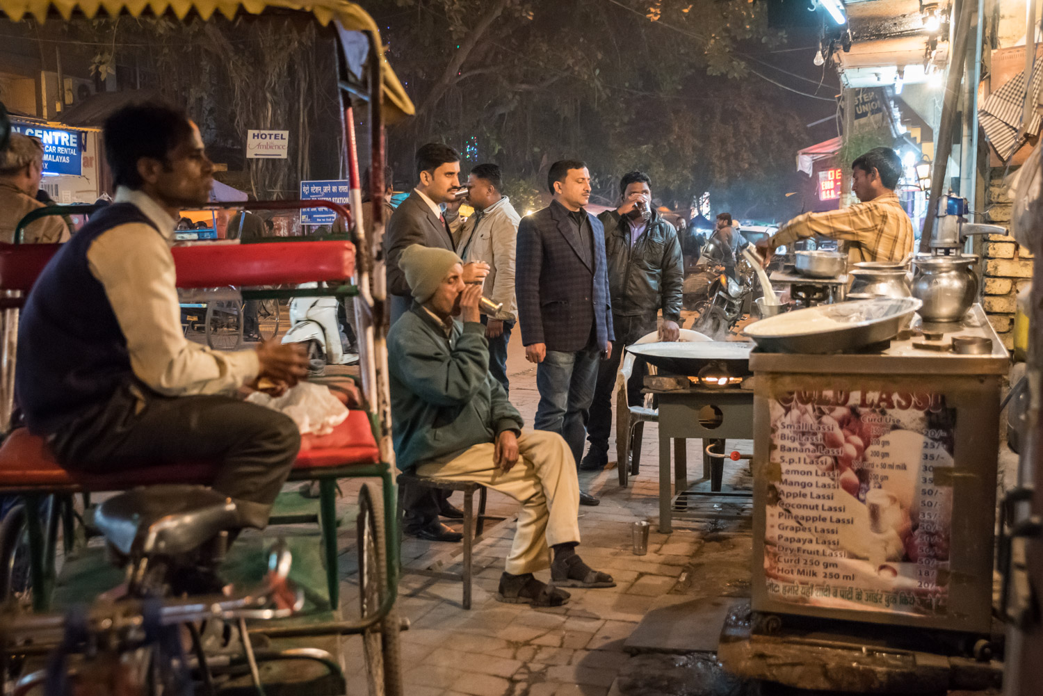
Men enjoy lassi and other milk drinks at a stand at night time on Main Bazar in the Paharganj neighbourhood of New Delhi. (© Richard McGuire Photo)

This man watches shoes for a few rupees in front of the Jama Masjid, the major mosque in Old Delhi. People must remove their shoes to enter the mosque. (© Richard McGuire Photo)

Hindu priests pour milk into the sacred Ganges River, often referred to as Mother Ganga. Milk is a symbol of fertility. (© Richard McGuire Photo)

Every evening there is an aarti ceremony with fire at Har-ki-Pauri ghats on the Ganges River at Haridwar, India. (© Richard McGuire Photo)

Hindu devotees place burning offerings adrift in the Ganges River at Har-ki-Pauri in Haridwar, one of India’s holy cities. (© Richard McGuire Photo)

This female rhesus macaque monkey thought I was too close when photographing her with her child, so she lunged at me with teeth bared. I backed away quickly, but not before snapping her in action. (© Richard McGuire Photo)

These men were making gulab jamun at a restaurant in Haridwar, India. This popular dessert is made with balls of milk solids deep fried and soaked in in a sugary syrup. (© Richard McGuire Photo)

This sadhu or holy man in Haridwar showed me his lair, built into a cave in a rock cut above the roadway. He had all his religious paraphernalia including a staff with the ancient swastika symbol on top. (© Richard McGuire Photo)

These girls came up to me and asked if they could take a photo of me with the digital camera the girl on the right is holding. For many Indians, the sight of a foreigner is a curiosity. I posed for them and then asked them to pose for me. In the background is the Residency, a complex in Lucknow where the British holed up for months while under siege by Indian rebels in 1857. (© Richard McGuire Photo)

A sadhu or Indian holy man poses for a photo at Sangam, the confluence of the holy Ganges and Yamuna rivers at Allahabad. (© Richard McGuire Photo)

A man takes an early morning dip in the holy Ganges River at Varanasi, India. Although the river is filled with sewage, industrial waste and cremated body parts, Hindus believe the river is sacred and pure and that bathing in it washes away sins. (© Richard McGuire Photo)

In Varanasi barbers work on the ghats beside the Ganges river, shaving heads or beards or both. (© Richard McGuire Photo)

At the end of morning aarti or prayer ritual, devout Hindus often touch the flames in an act of purification. Such rituals are regular every morning and evening along that ghats in Varanasi, India. (© Richard McGuire Photo)

The monkey was on a leash. The dog was not. These two played together on the ghats (steps to the river) in Varanasi. (© Richard McGuire Photo)

Bicycles and pedal rickshaws intersect at a busy intersection near the ghats in Varanasi. Although most motorized vehicles can’t enter this part during the daytime, motorcycles, unfortunately, can go anywhere they like. (© Richard McGuire Photo)

A priest is showered in flower petals that he has thrown into the air during the evening aarti ceremony by the Ganges in Varanasi. (© Richard McGuire Photo)

These were my fellow passengers on the train from Sanchi to Bhopal, that ran late. The man on the left spoke good English and he translated for the others, as I attempted also to communicate in my feeble Hindi. They had a lot of questions for me as it’s not usual for them to have a conversation with a foreigner. (© Richard McGuire Photo)

This group of Hindu men came to the Shipra River to bathe in the early morning at Ujjain in Madhya Pradesh. (© Richard McGuire Photo)

A Hindu man prays next to the Shipra River early in the morning in the holy city of Ujjain, Madhya Pradesh, India. (© Richard McGuire Photo)

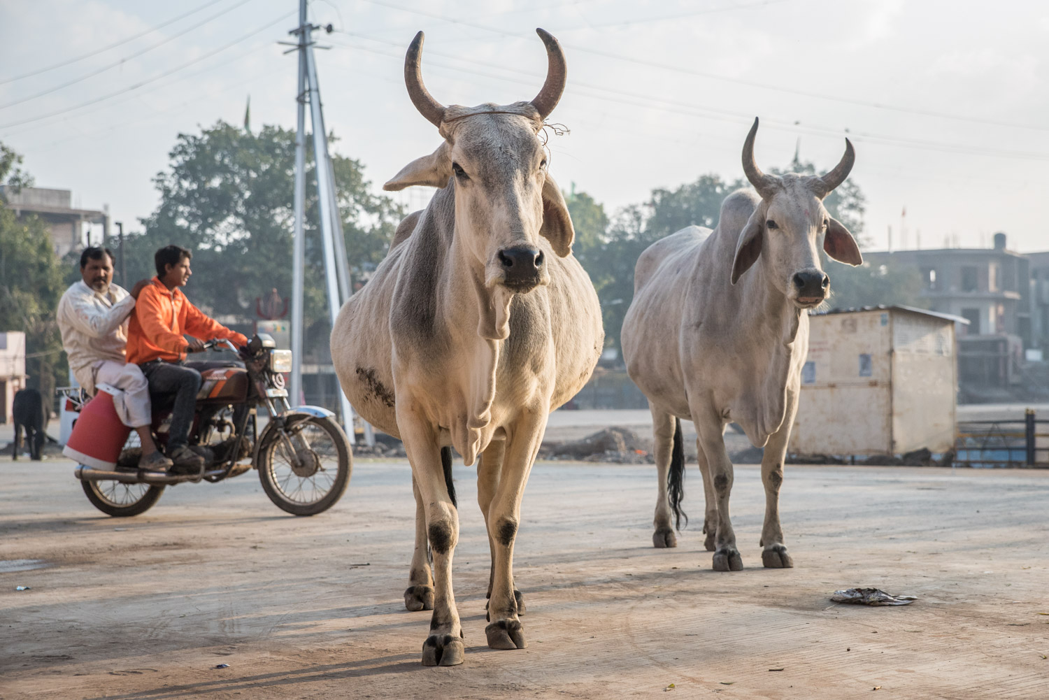
Two cows stand nonchalantly on a street in Ujjain, Madhya Pradesh as a motorcycle with two men drives past. Often motorcycles take numerous passengers — I’ve seen as many as a family of five — and very few people in India wear helmets. Sacred cows freely wander the streets and even railway stations throughout India. (© Richard McGuire Photo)

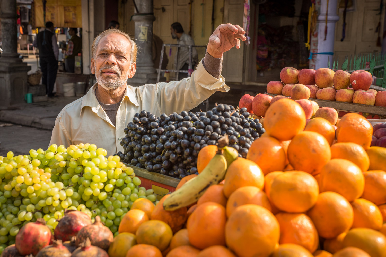
This fruit seller in Ujjain was selling grapes, pomegranates, oranges, bananas and apples. Ujjain is not touristy and people were friendly, often asking to pose when they saw my camera. (© Richard McGuire Photo)

A Hindu priest performs the evening aarti ceremony with fire beside the Shipra river in the holy city of Ujjain in Madhya Pradesh, India. (© Richard McGuire Photo)

The City Palace of Udaipur, Rajasthan is lit with lights at night that reflect in Pichola Lake. (© Richard McGuire Photo)

A young boy looks out his front door in the Blue City of Jodhpur, Rajasthan. Many houses in the blue city are covered with a blue wash. (© Richard McGuire Photo)

Children hang out in the Blue City of old Jodhpur. Many of the houses here are covered in a blue wash, which some say was originally to ward off insects. (© Richard McGuire Photo)

Sometimes in India you come across things on the street that have very little information attached. Such was the case with these figures on a street in Jodhpur, where I had to rely on my imagination. My guess, upon further reading, is that this is Rati on the left, the Hindu goddess of lust, passion and sexual pleasure with Kama, the god of love. (© Richard McGuire Photo)

A young girl balances carefully as she walks a rope below the fort at Jaisalmer, Rajasthan, hoping to earn rupees from impressed tourists. (© Richard McGuire Photo)

This old man was bundled up in a blanket to sip his tea and read his morning paper on a porch in Jaisalmer, Rajasthan. (© Richard McGuire Photo)

These construction workers were hauling bags of cement on a street in Jaisalmer, Rajasthan. They asked me to take a posed portrait of them, which I did. I then took a couple photos of them working. (© Richard McGuire Photo)

This woman asked to pose for a photo with her child for a few rupees. At first I refused her, but she persisted and I actually got a good smile from her. Many Rajasthani women dress very colourfully, but are shy about being photographed. (© Richard McGuire Photo)

A camel driver leads two camels across the sand dunes at sunset near Kanoi, an hour from Jaisalmer in Rajasthan. (© Richard McGuire Photo)

At the Karni Mata Temple in Deshnok, Rajasthan, rats feast on milk. The rats at this temple are venerated because they are believed to be the reborn ancesters of people in the community an hour south of Bikaner. Visitors to the temple need to remove their shoes as in any Hindu temple. There is rat feces on the ground and occasionally a rat will scurry across your foot. (© Richard McGuire Photo)

I met this regular winner of moustache growing contests, Vikram-ji, in the old city of Bikaner, Rajasthan. His moustache was tied up when I met him, but he unfurled it to show me. (© Richard McGuire Photo)

These colourfully dressed women pose for photos for tourists at Mehtab Bagh, a garden across the Yamuna River from the Taj Mahal. I got them to pose with the Taj in the background. (© Richard McGuire Photo)

Christmas and Boxing Day 2014 excursions

Horses feed on hay next to an abandoned house near Anarchist Summit to the east of Osoyoos, B.C. Snow falls gently at this higher elevation, even though there is no snow in the valley below.

I was dreaming of a green Christmas and I got it. But I took a drive up to Anarchist Summit to see the snow at the higher elevation. Christmas was grey, but Boxing Day was gorgeous. I took two walks to the end of Haynes Point Provincial Park, once in the morning by myself and again in the afternoon with Birgit. The park is on a long spit extending out into the lake and in the winter when the lake level is lower a sandspit extends beyond the park almost across the lake. © Richard McGuire Photo.

On a grey, clouding Christmas day the mountain range across the Similkameen Valley is visible from Anarchist Lookout.

A flock of Bohemian Waxwings visits Haynes Point Provincial Park near Osoyoos to feed on rosehips.

A flock of Bohemian Waxwings visits Haynes Point Provincial Park near Osoyoos to feed on rosehips.

Chunks of ice float in the water on the southern shoreline of Haynes Point Provincial Park near Osoyoos. They sounded like chimes as they bobbed up and down on the water, striking against each other.

Dried reeds stick out above the frozen surface of Osoyoos Lake of the southern shore of Haynes Point Provincial Park.

When the level of Osoyoos Lake is lowered in winter, a long sandspit extends from the end of Haynes Point almost across the lake.

When the level of Osoyoos Lake is lowered in winter, a long sandspit extends from the end of Haynes Point almost across the lake.

When the level of Osoyoos Lake is lowered in winter, a long sandspit extends from the end of Haynes Point almost across the lake.

Most of the South Basin of Osoyoos Lake is still open water in late December. Only a little ice appears on the southern shorelines of Haynes Point Provincial Park. In the distance is Washington State.

The water is calm on Osoyoos Lake, looking north from Haynes Point to the town of Osoyoos.

Looking south on Osoyoos Lake from Haynes Point Provincial Park. Washington State is in the distance.


Visit to Ken Helm’s car farm and village

Ken Helm shows off an early Buick he is reconstructing from parts acquired from many sources. His workshop is filled with various car parts, tools and just about anything else. (© Richard McGuire Photo)

Ken Helm is a friendly, but eccentric man living in Cawston, B.C. who has the largest collection of cars, old buildings and memorabilia I’ve ever seen. On Sunday a group of us from the Penticton Photography Club had a chance to visit his farm and meet him. He’s moved buildings from all over to his farm and they form a virtual village. Workshops, garages and other buildings are packed with car parts and antiques. Down the hill from the “village” is a boneyard containing vehicles from the 1940s, 1950s and earlier. No doubt every photographer got a very different take on it, but all agreed it was a photographer’s paradise. I’ve added a few photos at the end here from a return visit in 2016. (© Richard McGuire photo)

The remains of of an antique car sit outside in their resting place on the farm of collector Ken Helm near Cawston, B.C. (© Richard McGuire Photo)

This assortment of parts and tools on one of Ken Helm’s workbenches is typical of what can be found in his workshop. (© Richard McGuire Photo)

This BMW Isetta in one of Ken Helm’s workshops near Cawston was a popular car in Europe in the 1950s following the Suez Crisis because it had excellent fuel economy. You open the front to get in, pulling the steering wheel and dashboard out on the door. It had a motorcycle style engine. (© Richard McGuire Photo)

This enclosed porch is home to a large collection of memorabilia on Ken Helm’s farm near Cawston, B.C. (© Richard McGuire Photo)

Below a laneway lined with old buildings and down a hill at Ken Helm’s farm near Cawston is a boneyard of old vehicles ranging from early DeSotos, Hudsons, Mercurys and dozens of old Volkswagen Beetles. (© Richard McGuire Photo)

Time has stood still in this old Mercury in the boneyard at Ken Helm’s farm near Cawston, B.C. (© Richard McGuire Photo)

This classic old Pontiac sits among other 1950s and earlier cars in the boneyard at Ken Helm’s farm near Cawston. (© Richard McGuire Photo)

This classic old Pontiac has bench seats and original components, but the interior is a bit worse for wear. It is among the cars in the boneyard at Ken Helm’s farm near Cawston. (© Richard McGuire Photo)

The remains of of an antique Ford sit outside in their resting place on the farm of collector Ken Helm near Cawston, B.C. (© Richard McGuire Photo)

The grille of and old Ford truck tells stories in its peeling paint and rust at the farm of Ken Helm near Cawston, B.C. (© Richard McGuire Photo)

Ten years ago Tony was passing through Cawston on his way to Australia. Ken Helm invited him to stay and now he fits right in with the collection of old buildings, vehicles and memorabilia, living in an old shop. I first met Tony at a farmers’ market in Kaslo during the summer. (© Richard McGuire Photo)

Tony took me up a fruit picking ladder to the rooftop of one of the wooden buildings at Ken Helm’s farm that afforded a nice view of the Savona Garage, one of the buildings on the main street. (© Richard McGuire Photo)

An old car is parked next to the Corona Court Cafe Cabins at Ken Helm’s farm near Cawston. (© Richard McGuire Photo)

An old 1948 license plate gathers rust among vehicle parts at Ken Helm’s farm near Cawston, B.C. (© Richard McGuire Photo)

Ken Helm gestures as he talks to visitors. He’s now retired, but his impressive collection of old vehicles keeps him busy. (© Richard McGuire Photo)

Many of the old cars had wooden spokes. This one even has tires too. (© Richard McGuire Photo)

A classic gas pump still measures in gallons. No doubt fuel was much cheaper when it was working. Now it sits outside one of the buildings on Ken Helm’s farm near Cawston, B.C. (© Richard McGuire Photo)

Ken Helm (left) and Tony agreed to pose for a photo next to one of the garages on Ken’s farm near Cawston. Both men would do very well in a beard growing contest. (© Richard McGuire Photo)

Ken Helm returns home with the youngsters and dog in one of his many fixed up cars. (Richard McGuire photo)

The vanes or wings of this Radiometer Space Age Sphere spin as the temperature warms them unevenly. (Richard McGuire photo)

The distributor and spark plugs on this old 1916 Buick that Ken Helm is restoring show that the mechanics of century-old vehicles were an art form. (Richard McGuire photo)

Old chains and gears collect dust and cobwebs in one of Ken Helm’s workshops. (Richard McGuire photo)

Autumn Sunday in the Okanagan

Leaves lie on the ground in an orchard near Osoyoos.

It was a pleasant, sunny Sunday, the first day of Standard Time. I took a drive to admire the colours of autumn in the orchards and vineyards around Osoyoos. (Richard McGuire Photo)

Vineyards of different types of grapes turn different colours in autumn in this photo north of Osoyoos.

Grape leaves turn colours as some of the red varieties still remain to be picked.

Grape leaves turn colours as some of the red varieties still remain to be picked.

Late afternoon sun strikes the rows of grapes in a vineyard north of Osoyoos.

Different varieties of grapes turn different colours in autum north of Osoyoos.

Golden sunlight strikes the vineyards in the foreground while farms in the shadow of Mount Kobau have descended into shade.

A vineyard near Okanagan Falls.

The setting sun lights up clouds above Vaseux Lake as yellow vines still give off a glow.

As dusk falls, deer become active. This is on conservation land, but nearby vineyards have high fences, sometimes electrified, to keep the deer out.

Nicola country and Lillooet revisited

A fisherman casts his line in Lower Joffre Lake in Joffre Lakes Provincial Park. The park is east of Pemberton, B.C.

I returned to Squamish to pick up my car nearly a week after breaking the oil pan and got it back on the road. I was determined to pick up where I left off, exploring the mountainous country between Pemberton and Lillooet and continuing on through Cache Creek and finally back to Merritt. The trip took me through the upper Fraser River and Thompson River country, as well as up narrow valleys of smaller rivers. This time I stuck to the paved roads. (Richard McGuire Photo)

A glacier covers a peak beyond Joffre Lakes Provincial Park east of Pemberton, B.C.

Trees cling to a sheer rock face on mountains west of Lillooet, B.C.

Lillooet on the upper Fraser River boasts of being “guaranteed rugged.” The rocky and mountainous landscape certainly meets that description.

Morning sunlight catches the vegetation at the east end of Seton Lake just west of Lillooet, B.C.

Trees are reflected in the still waters of Pavilion Lake on the road between Lillooet and Cache Creek, B.C.

An old log building sits in a field on a ranch next to the road between Lillooet and Cache Creek, B.C.

A long train loaded with containers snakes through tunnels next to the Thompson River in the arid countryside near Ashcroft, B.C.

Horses graze on open land near Merritt, B.C.

Adventure trip to the Nicola Valley and Lillooet country

An old farmhouse in Lower Nicola sits decaying.

I took a driving trip on the Labour Day weekend to the lovely Nicola Valley near Merritt, B.C. and continued on through the Thompson and Fraser River valleys to Lillooet and beyond. The journey got more and more rugged until I found myself on a narrow, rough mountain road in very wild country.

Unfortunately I bumped a rock on the road which broke my car’s oil pan. I had to shut off my engine and coast with no power steering or power brakes down the mountain on a twisty dirt road to an Indian reserve where I was able to call a tow truck. My CAA Plus membership has now paid for itself many times over!

The adventure isn’t over because I now have my car waiting to be repaired in Squamish and I have to get back to work in Osoyoos for production day on Tuesday. I was, however, able to get a couple nice photos of a rainbow, which hopefully will bring some luck. (Richard McGuire Photo)

Scw’Exmx Parish Church in Lower Nicola is a wooden church in the style of many old First Nations churches build in the late 19th century and early 20th. It looks like it has seen better days.

Hay dries in the Nicola Valley of British Colimbia.

The Nicola River flows through lusher valleys before crossing into an arid area and emptying into the Thompson River at Spences Bridge.

There are many cattle ranches in the Nicola Valley, like this one that displayed a cow’s skull over its gate.

The Nicola River flows through lusher valleys before crossing into an arid area and emptying into the Thompson River at Spences Bridge.

The Nicola River flows through lusher valleys before crossing into an arid area and emptying into the Thompson River at Spences Bridge.

In many of the First Nations communities especially, livestock wanders on the highway, Horses have the right of way.

The Nicola River enters drier terrain as it approaches the arid area where it empties into the Thompson River at Spences Bridge.

A bighorn ewe munches on salad at the side of the highway in the Nicola Valley of British Columbia.

Hoodoos and earth formations rise above the highway in the lower Nicola Valley. In this dry land, water and wind erode the sides of the valley.

Hoodoos and earth formations rise above the highway in the lower Nicola Valley. In this dry land, water and wind erode the sides of the valley.

Lillooet, on the upper Fraser River of British Columbia, bills itself as guaranteed rugged. Those looking to enjoy the wilderness won’t be disappointed.

Sunflowers grow by an old wooden church in Lillooet, B.C.

The Fraser River flows through a narrow valley near Lillooet before descending down a steep canyon further downriver.

These old log houses are northwest of Lillooet in the Bridge River Valley.

This mountain road was very good by the standards of roads yet to come. Nonetheless, the lack of guard rails, and the steep valley was a reminder to drive carefully, especially where slides had dropped rocks on the road. At lower right is the shell of a car that looked like it went over the edge long ago.

Carpenter Lake Road made a series of hairpin turns on its descent to Mission Mountain Road.

Bridge River flows through rocky terrain below a large dam at Carpenter Lake. This is the wild country west of Lillooet.

As you descend Shalaith Road from a steep mountain pass, you see spectacular views of Seton Lake to the west of Lillooet, B,C.

At Seton Portage, as I approached Anderson Lake, the clouds darkened and winds surged while sunlight tried to shine through the clouds and rain. It was a dramatic scene.

At Seton Portage, as I approached Anderson Lake, the clouds darkened and winds surged while sunlight tried to shine through the clouds and rain. It was a dramatic scene.

As I looked back at where a sudden storm had blown through, I saw a double rainbow over the mountains. It seemed like magic.

As I looked back at where a sudden storm had blown through, I saw a double rainbow over the mountains. It seemed like magic.

On a very rough and narrow mountain road, my car’s oil pan was shattered by a rock. My only blessing was that it was all downhill to the N’Quatqua Band Indian Reserve. I turned off my engine, put the car in neutral and rolled down the mountain, working hard to steer and brake without power steering or brakes. I made it to this village where an old church stood opposite the convenience store and I called a tow truck.

A May Sunday in the South Okanagan Grasslands

This little lake next to Kruger Mountain Road is currently surrounded by lush green spring vegetation. Many water birds and others were congregating here.

When I need to recharge my batteries, one of my favourite short trips — about 15 minutes outside Osoyoos — is the South Okanagan Grasslands, Kilpoola Lake and the Sage and Sparrow Conservation Area. It’s accessible by a rough and narrow dirt road that’s probably better suited for a 4X4, but is passable in my VW Golf when it’s dry. This Mother’s Day Sunday the weather was perfect — low 20s — and I spent several hours up there. (© Richard McGuire Photo)

It’s called Blue Lake, but this lake next to Kruger Mountain Road is very green in colour. It is surrounded by flowering bushes.

Kruger Mountain Road is more of a dirt track that becomes narrower and rougher the farther in you go. It winds through forests before emerging in the grasslands.

Kilpoola Lake is a small lake surrounded by grasslands. On a May weekend, a number of people came to fish for rainbow trout, which the lake is stocked with each year.

Cattle cool their heels at the shore of Kilpoola Lake. Cattle ranching is done on parts of the South Okanagan Grasslands.

The road peters out as it crosses a cattle range. This mother and calf stood blocking my car and refused to move. I had to inch closer and closer and they didn’t budge until I was within a couple feet of them.

Kilpoola Lake is surrounded by sweet-smelling sagebrush. On a pleasant May weekend, there was still a lot of green. Later in the summer the area becomes much drier.

The road into Kilpoola Lake is narrow and dirt. It winds through grasslands with sagebrush and the occasional aspen.

A few people fish in boats on small Kilpoola Lake on a May weekend. The lake is stocked each year with rainbow trout.

Clusters of aspens are bright green amidst the sagebrush of the South Okanagan Grasslands above Kilpoola Lake.

On a May weekend there is still snow on the mountains across the Similkameen Valley. A narrow rough road leads into the Sage and Sparrow Conservation Area.

Yellow arrowleaf balsamroot flowers dot the hillside in the Sage and Sparrow Conservation Area.

My little Volkswagen Golf isn’t the best vehicle for exploring some of the rough dirt roads of the South Okanagan Grasslands. Many people opt for 4X4 trucks instead. There’s no room for passing.

On a May weekend there is still snow on the mountains across the Similkameen Valley. This area is right on the Canada-U.S. border, which is more of an invisible line here.

From this hilltop in the South Okanagan Grasslands, you look down into the Similkameen Valley. This point is in Canada, but the valley is in the United States.

Fluffy cumulus clouds roll over the South Okanagan Grasslands, casting moody shadows.

Fluffy cumulus clouds roll over the South Okanagan Grasslands, casting moody shadows.


Spring in Osoyoos, B.C.

A bee feeds on nectar in an Okanagan orchard. (Richard McGuire photo)

Throughout April, many flowers in Osoyoos break out in bloom. I especially like the blossoms in the orchards because they mean that fresh fruit like cherries, apples, peaches, nectarines, plums and pears are on their way. (Richard McGuire Photo)

A bee feeds on nectar in an Okanagan orchard. (Richard McGuire photo)

Apple blossoms form a canopy over rows in an orchard on the edge of Osoyoos, B.C. © Richard McGuire Photo

A yellow forsythia bush and yellow tulip glow in the sunlight of a spring day on Osoyoos Lake, B.C. © Richard McGuire Photo

A sign of spring is a flowering magnolia tree. These grow easily in the warm climate of Osoyoos, B.C., but don’t do so well in long cold winters of some other parts of Canada. © Richard McGuire Photo

  • The barn at Haynes Ranch
  • White Lake
  • Rock formations near White Lake
  • Custom Crafted Home
  • Custom Crafted Home
  • Naramata from the Kettle Valley Railway Trail
  • Okanagan Mountain Provincial Park
  • Okanagan Mountain Provincial Park
  • Okanagan Mountain Provincial Park
  • Okanagan Mountain Provincial Park
  • Higher elevation

A spring Sunday outing in the Okanagan-Similkameen

One of the great things about the South Okanagan-Similkameen region of British Columbia is that you can experience very different landscapes and climates in a very short period of time.

On Sunday, a warm spring day, I took a meandering drive along the back roads of the Okanagan Valley, crossing into the neighbouring Similkameen Valley and back again.

In a very short distance, I passed through wetlands, desert, spreading vineyards, forests of different types and mountain scenery. There were deep blue lakes and a few shallow saline ones. There were cattle and horse ranches and vast expanses of wilderness. Cities, villages and little hamlets. Spreading mansions and tiny hovels.

At the farthest part of my journey, I continued north from Penticton along the eastern shore of Okanagan Lake, past the vineyards of Naramata, and up a twisty dirt mountain road towards Chute Lake. It was a journey I’d never made before, even though it is just an hour and a half from where I live. There, earlier fires have left stick-like trees dotted across the rugged mountains of Okanagan Mountain Provincial Park.

Although the temperature was warm, there was still a lot of snow at the elevation of around 4,000 feet making it impossible to explore further. I took a few photos and made a mental note to come back again when the snow is gone.

An old barn is reflected in one of the oxbows at the historic Haynes Ranch just north of Osoyoos, B.C. (Richard McGuire Photo)

An old barn is reflected in one of the oxbows at the historic Haynes Ranch just north of Osoyoos, B.C. (Richard McGuire Photo)

Clouds cast shadows over the mountains and grasslands at White Lake, north of Oliver, B.C. The small saline lake is surrounded by sagebrush and is in a protected area. (Richard McGuire Photo)

Clouds cast shadows over the mountains and grasslands at White Lake, north of Oliver, B.C. The small saline lake is surrounded by sagebrush and is in a protected area. (Richard McGuire Photo)

Steep rock formations rise from the sagebrush grasslands near White Lake, north of Oliver, B.C. (Richard McGuire Photo)

Steep rock formations rise from the sagebrush grasslands near White Lake, north of Oliver, B.C. (Richard McGuire Photo)

Hand-crafted custom home, open concept, lovely mountain views in every direction. Beautiful skylights. Great starter home for a handyman willing to give it some TLC. (Richard McGuire Photo)

Hand-crafted custom home, open concept, lovely mountain views in every direction. Beautiful skylights. Great starter home for a handyman willing to give it some TLC. (Richard McGuire Photo)

Hand-crafted custom home, open concept, lovely mountain views in every direction. Beautiful skylights. Great starter home for a handyman willing to give it some TLC. (Richard McGuire Photo)

Hand-crafted custom home, open concept, lovely mountain views in every direction. Beautiful skylights. Great starter home for a handyman willing to give it some TLC. (Richard McGuire Photo)

A hiking and biking trail now follows the former bed of the Kettle Valley Railway in the Okanagan Valley and beyond. The view of Okanagan Lake and the wine country around Naramata is spectacular from this portion of the trail. (Richard McGuire Photo)

A hiking and biking trail now follows the former bed of the Kettle Valley Railway in the Okanagan Valley and beyond. The view of Okanagan Lake and the wine country around Naramata is spectacular from this portion of the trail. (Richard McGuire Photo)

The barren rock of Okanagan Mountain rises above the forests east of Okanagan Lake between Penticton and Kelowna. Some of the higher forests have seen fire damage in past years. This view was taken from Chute Lake Road. (Richard McGuire Photo)

The barren rock of Okanagan Mountain rises above the forests east of Okanagan Lake between Penticton and Kelowna. Some of the higher forests have seen fire damage in past years. This view was taken from Chute Lake Road. (Richard McGuire Photo)

The barren rock of Okanagan Mountain rises above the forests east of Okanagan Lake between Penticton and Kelowna. Some of the higher forests have seen fire damage in past years. This view was taken from Chute Lake Road. (Richard McGuire photo)

The barren rock of Okanagan Mountain rises above the forests east of Okanagan Lake between Penticton and Kelowna. Some of the higher forests have seen fire damage in past years. This view was taken from Chute Lake Road. (Richard McGuire photo)

The barren rock of Okanagan Mountain rises above the forests east of Okanagan Lake between Penticton and Kelowna. Some of the higher forests have seen fire damage in past years. This view was taken from Chute Lake Road. (Richard McGuire Photo)

The barren rock of Okanagan Mountain rises above the forests east of Okanagan Lake between Penticton and Kelowna. Some of the higher forests have seen fire damage in past years. This view was taken from Chute Lake Road. (Richard McGuire Photo)

The barren rock of Okanagan Mountain rises above the forests east of Okanagan Lake between Penticton and Kelowna. Some of the higher forests have seen fire damage in past years. This view was taken from Chute Lake Road. (Richard McGuire photo)

The barren rock of Okanagan Mountain rises above the forests east of Okanagan Lake between Penticton and Kelowna. Some of the higher forests have seen fire damage in past years. This view was taken from Chute Lake Road. (Richard McGuire photo)

There's still snow, ice and ponds of meltwater at higher elevations along Chute Lake Road, north of Penticton. The road passes close to Okanagan Mountain Provincial Park, seen in the background. Although there was still substantial snow in some places at this elevation of nearly 4,000 feet, the air temperature was close to 20 C. New growth is springing up on land once burned by forest fire. (Richard McGuire photo)

There’s still snow, ice and ponds of meltwater at higher elevations along Chute Lake Road, north of Penticton. The road passes close to Okanagan Mountain Provincial Park, seen in the background. Although there was still substantial snow in some places at this elevation of nearly 4,000 feet, the air temperature was close to 20 C. New growth is springing up on land once burned by forest fire. (Richard McGuire photo)