Until this past weekend, the Chilcotin and Bella Coola Valley were major areas of B.C. I had not yet visited. I’ve been wanting to go for several years, but only now had the chance for a brief trip. I’ve watched the wildfire situation for a while, knowing it could disrupt plans, but in the end I decided to chance it. There was smoke much of the way, but I tried to make the best of it to capture some different landscape images. (© Richard McGuire Photo)


North of Anahim Lake, the sky filled with an ominous, massive cloud of wildfire smoke. Beside it, to the left, the sky was clear. The sun casts an eerie orange glow through the smoke. (© Richard McGuire Photo)

Fog clings close to the ground as smoke from wildfires fills the air north of Princeton in cattle ranching country. (© Richard McGuire Photo)

Warning people not to pollute the air by idling their cars is a good message, but it will do little to improve air quality here — at a lookout next to Highway 20 west of Williams Lake. Wildfire smoke pushed air pollution levels to 10+ that day. (© Richard McGuire Photo)

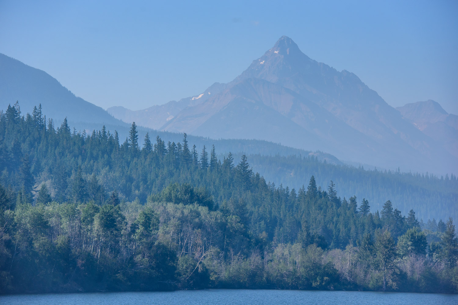
After camping by Horn Lake in Chilcotin, I left my trailer in the campsite and took a drive down to Bluff Lake. There was some blue in the sky, but wildfire smoke cast a haze over the Coast Mountains. (© Richard McGuire Photo)

After camping by Horn Lake in Chilcotin, I left my trailer in the campsite and took a drive down to Bluff Lake. There was some blue in the sky, but wildfire smoke cast a haze over the Coast Mountains. (© Richard McGuire Photo)

Chipmunks are skittish too, but they will pose if you stay a respectful distance. Another use for the 600 mm lens. (© Richard McGuire Photo)

South of Nimpo Lake I drove through thick wildfire smoke, which abruptly ended as I drove out into blue sky. A helicopter passes overhead surveying the wildfire’s growth. (© Richard McGuire Photo)

North of Anahim Lake, the sky filled with an ominous, massive cloud of wildfire smoke. Beside it, to the left, the sky was clear. (© Richard McGuire Photo)

North of Anahim Lake, the sky filled with an ominous, massive cloud of wildfire smoke. Beside it, to the left, the sky was clear. The sun casts an eerie orange glow through the smoke. (© Richard McGuire Photo)

North of Anahim Lake, the sky filled with an ominous, massive cloud of wildfire smoke. The sun casts an eerie orange glow through the smoke. (© Richard McGuire Photo)

Wildfire smoke from a blaze to the north fills the sky at the eastern entrance to Tweedsmuir Provincial Park. This area has seen fires in past years, as evidenced by the burnt bark on dead trees and the abundant fireweed growing below. This pink flower is one of the first to establish after a fire. (Richard McGuire Photo)

The Heckman Pass in Tweedsmuir Provincial Park is the road access to the Bella Coola Valley. But it’s at 1,524 metres — 5,000 ft. — and the descent is very steep and twisty. It’s called “The Hill” and while it can be very dangerous in the wrong conditions, it’s not that hard with caution, a mechanically sound vehicle and no bad weather. The bottom of The Hill was around 325 metres or 1,000 feet according to my GPS. (© Richard McGuire Photo)

As I reach the first hairpin down, the road has been quite steep, but doable, and the road is wide, well graded and with a fair number of pullouts. Note the clear sky over the valley, but smoke clouds drifting in from the northeast. (© Richard McGuire Photo)

There are no railings or curbs beside the road anywhere on “The Hill,” but that’s not unusual in B.C. Beside this pullout, cliffs drop down to the next switchback far below. At the bottom is the Atnarko Valley. (© Richard McGuire Photo)

I stopped regularly at pullouts to take pictures. I’m towing a 1979 Triple E Surfside fibreglass eggshell trailer behind a 2008 Jeep Liberty with standard transmission. I’m well off the road, but I’m not parked too close to the steep edge. I also make sure I’m standing on stable ground. (Richard McGuire Photo)

Looking down from the pullout, I see the next switchback far below. This area has some steep descents and some narrow stretches. (© Richard McGuire Photo)

The road narrows neveral places around here where it skirts a cliff. It’s wide enough that two cars can squeeze past, but larger vehicles may have problems. Descending vehicles should yield to those making the climb. There are regular pullouts. (© Richard McGuire Photo)

I now tow my 1979 Triple E Surfside behind a 2008 Jeep Liberty with standard transmission. Last year I used an aging VW Golf diesel standard, which could handle more modest climbs, it could not have climbed up “The Hill.” (© Richard McGuire Photo)

Below “The Hill” is the Atnarko Valley. The rugged landscape made road building difficult when it was built in the early 1950s. Incredibly, the government rejected building a road as too costly, but locals banded together and built it themselves — calling it “The Freedom Road.” (© Richard McGuire Photo)

I decided to check out the Mccall Flats recreation site for camping, but the road was too rough with the trailer, so I didn’t go all the way. I did enjoy the views from the bridge over the Bella Coola River. They don’t allow tents because of the local bear population, so it looks like your best option would be a truck camper. (© Richard McGuire Photo)

This was the clearest evening I’ve seen since the beginning of July as there was hardly any smoke. You can even make out details of the half moon above the mountains around Hagensborg. (© Richard McGuire Photo)

With only the slightest amount of smoke, the sinking sun casts its golden light on the mountains around Hagensborg, where I camped. (© Richard McGuire Photo)

I was looking forward to getting up early and enjoying another clear day. But the otherworldy sunrise was because of the advancing smoke that moved into the Bella Coola Valley. (© Richard McGuire Photo)

Framed by many of the washed-up stumps on the shore, a big, hulking abandoned fish cannery sits out on the water next to the Bella Coola harbour. (© Richard McGuire Photo)

The Bella Coola Harbour is mainly fishing boats that travel out on the North Bentinck Arm to fishing waters. (© Richard McGuire Photo)

A big, hulking abandoned fish cannery sits out on the water next to the Bella Coola harbour. (© Richard McGuire Photo)

A bald eagle takes flight where Clayton Falls Creek empties into the North Bentinck Arm. There’s a recreation site there operated by BC Hydro. (© Richard McGuire Photo)

Although it’s past the middle of August, snow and glacier ice clings to the tops of some of the mountains overlooking the North Bentinck Arm near Bella Coola. (© Richard McGuire Photo)

Water has sculpted the rocks at Clayton Falls, just up the creek from the North Bentinck Arm west of Bella Coola. BC Hydro operates a recreation site here, and there is a platform to view the falls. A graphic sign shows what happens to people who get sucked into the undertow of the pool below the falls. (© Richard McGuire Photo)

Water has sculpted the rocks at Clayton Falls, just up the creek from the North Bentinck Arm west of Bella Coola. BC Hydro operates a recreation site here, and there is a platform to view the falls. A graphic sign shows what happens to people who get sucked into the undertow of the pool below the falls. (© Richard McGuire Photo)

I took a short stroll onto a mostly dried streambed, strewn with cut logs. I never saw a bear, but I had my spray just in case. Hint: you don’t use the spray on yourself like mosquito repellent. (© Richard McGuire Photo)

A sign indicates the steep grades descending “The Hill” from Heckman Pass. At one point low down the sign is posted at 15%, though the road is said to have part at 18%. Most is 10 and 11% grade. (© Richard McGuire Photo)

North of Anahim Lake, the smoke became especially thick on the return trip. Vehicles drove with headlights and visibility was very limited. (© Richard McGuire Photo)

These cattle posed a roadblock on a bridge near Kleena Kleene. I don’t know if they wanted me to pay a toll, but I inched around them and they inched to the side. Cattle and horses aren’t fenced in this open rangeland, so you have to drive carefully. (© Richard McGuire Photo)

I drove fairly non-stop on the return through smoke along Highway 20. Williams Lake was less smoky than on my way up, but after stopping for gas, I continued down Highway 97. I opted to camp at Green Lake Provincial Park near 70 Mile House. (© Richard McGuire Photo)